Live on the road
The San Antonio Mission Trail Audio Tour
Whistlestop narrates far more of the drive than this guide can list, automatically, as you pass each one.

The field guide
Why here
San Antonio exists because of a geological accident about twenty miles wide. The Balcones Escarpment runs across Texas here, a fault zone where the Edwards Plateau drops away to the coastal plain, and the limestone of the Edwards Aquifer is cut off along it. Water that fell as rain on the Hill Country moves south through the rock and has nowhere to go but up, and along the fault line it comes out as springs.
The San Antonio River is one of those. It rises in a city park a few miles north of downtown and it is spring-fed rather than rain-fed, which in South Texas is the whole difference: it ran in drought years when everything around it did not. The Payaya people who lived at the headwaters called the place Yanaguana. A Spanish expedition camped there on the feast of Saint Anthony of Padua in 1691 and renamed the river for him, and the name stuck to everything afterwards.
That is why five missions ended up on ten miles of one small river instead of spread across a province. Spanish mission siting had three requirements, reliable water, workable farmland and people to convert, and this stretch was the only place on the northern frontier that offered all three at once. Four of the five were not even founded here. They were begun in East Texas, near the French in Louisiana, and were moved west when that frontier failed.
The ditches
The missions are the buildings people photograph, and the acequias are the reason the buildings are there. Within about thirty years of arriving, the Spanish and the mission communities had dug eight gravity-fed canals totalling roughly fifteen miles, with dams, floodgates, sluices and one aqueduct, irrigating something over 3,500 acres. It is among the earliest engineered water supply systems anywhere in what is now the United States, and the American Society of Civil Engineers lists it as a historic landmark.
The technique is not Spanish in origin. Acequia comes from the Arabic as-saqiya, the water conduit, and the Spanish learned it during eight centuries of Moorish rule in Iberia and carried it to the Americas. What was dug in Texas in the 1730s and 1740s is a North African irrigation system mediated through Spain and built largely by Coahuiltecan hands.
Two of the eight are still running. The Espada acequia has never stopped and is generally called the oldest continually operating irrigation system in the United States: the dam turns river water into it, the aqueduct carries it over a creek, and it waters fields at Mission Espada as it has since the 1740s. The San Juan acequia had been dry for decades until a restoration finished in 2011 put water back in its 6.7 miles.
The most satisfying thing on this whole trail is what that ditch is doing now. The San Antonio Food Bank farms 45 acres at Mission San Juan, irrigated off the rebuilt acequia, growing produce for people in the city who need it. A three hundred year old ditch, dug by people who were being colonised, is feeding the descendants of everyone involved.
What a mission actually was
Not a church with some outbuildings. A mission was a walled town built to turn hunter-gatherers into Spanish Catholic farmers within a generation, and the church was one building in it. Inside the walls were quarters for hundreds of people, a granary, a mill, workshops for weaving and carpentry and blacksmithing, kilns, a well; outside were the irrigated fields, and beyond those a ranch. Mission Espada's ranch, Rancho de las Cabras, was 35 miles south near Floresville, and its stone perimeter wall and tower bases are still there.
The dates run 1718 to 1731 and then stop. Valero came first, in 1718. San José followed in 1720. The other three were all refounded on the same day, 5 March 1731, having been carried west from East Texas after the missions there failed against French competition, disease and Indigenous resistance. Four days later the Canary Islanders arrived to found the civil town, and the shape of Spanish San Antonio was set in a single week.
They were also temporary by design. A mission was supposed to work itself out of a job and hand its lands to its residents as an ordinary parish. That process, secularisation, began in 1793 at Valero and ran through the 1790s at the others, with the last transfers completing in 1824 under Mexico. The system lasted about a century.
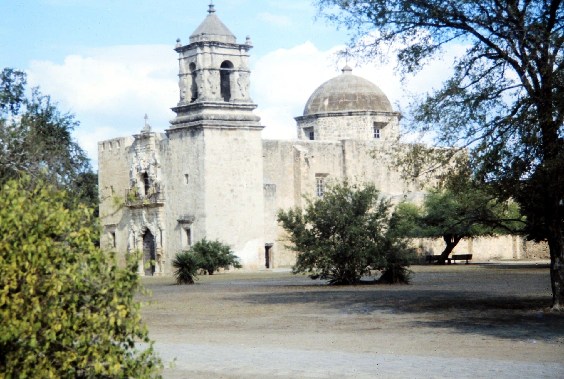
What is left has been treated very differently. San José was substantially rebuilt: its church had been closed since 1868 and its dome and roof were restored by 1937 by the WPA, the San Antonio Conservation Society and Bexar County working together, and the sacristy window was reworked between 1947 and 1952. Concepción was never rebuilt at all, which is the source of its claim to be the oldest unrestored stone church in the country. Espada and San Juan sit somewhere between.
About that window. The sacristy window at San José is the most photographed piece of Spanish colonial carving in North America, and nearly every account names Pedro Huízar as its sculptor and tells you he named it for a lost love called Rosa. A National Park Service study completed in 1981 established that Huízar, a real man who really worked at San José as a carpenter and surveyor, did not arrive until the 1790s, roughly twenty years after the window was cut. The Rosa story appears to be a nineteenth century invention, the flowers in the stone may be pomegranates, and the likelier explanation of the name is Saint Rose of Lima. Nobody knows who carved it.
The people the missions were built for
The Spanish lumped dozens of distinct bands under one word, Coahuiltecan, which was never a nation or a language so much as a label applied from outside to the hunter-gatherer peoples of South Texas and northeastern Mexico. They had been here for thousands of years before anyone wrote the word down.
They did not walk into the missions because the argument was persuasive. They came under compression from several directions at once: Apache and later Comanche pressure pushing south, European epidemics running ahead of European settlers, and the loss of the land, water and game that a mobile life needs. A walled compound with stored grain and a garrison was, for a great many people, the least bad option available. What it cost was most of what made them who they were. Within a few generations languages and religions had largely gone, absorbed into a Spanish-speaking Catholic culture that is still the culture of South Texas.
It would be easy to write that in the past tense, and it would be wrong. Descendants of the mission communities are here, worshipping in the same four churches. The Tāp Pīlam Coahuiltecan Nation, which is not federally recognised, traces its ancestry to these missions including Valero, and in 2019 it sued the Alamo Trust, the Texas General Land Office, the Texas Historical Commission and the City of San Antonio over exclusion from archaeological decisions and ceremonies at the Alamo, where burials lie under a site being redeveloped. The case settled on 30 May 2022, approved by the city council that June. It carried no money. What it gave was an invitation to oversight meetings without a vote, consultation on programming, and extended access on the second Saturday of September for ceremony.
It is worth knowing that before you stand in any of these churches, because it is the difference between a ruin and a parish. All four of the mission churches on this trail hold Mass. The National Park Service owns and maintains the buildings; the Archdiocese of San Antonio uses them, on Sundays, for the people who live around them.
How one of the five became something else
Valero was secularised in 1793 and its buildings went to other uses, which on a contested frontier meant soldiers. A Spanish cavalry company quartered in the old convento, and the name they brought with them from Álamo de Parras in Coahuila attached itself to the compound. By the 1830s the mission was a fort with a roofless, unfinished church in it.
The siege began on 23 February 1836 and ended on the morning of 6 March, thirteen days later, with a final assault that took about ninety minutes. The official list of defenders currently holds 189 names and continuing research may push the figure toward 257. William Barret Travis and James Bowie shared command until Bowie fell ill; Antonio López de Santa Anna commanded the Mexican army.
The building most people picture is partly a later invention. The church was a roofless ruin for years afterwards, and in 1850 the US Army quartermaster Edwin Burr Babbitt roofed it and added the curved parapet across the top of the façade, probably to a design by the architect John M. Fries. A daguerreotype from 1849 is the only photograph of the church before that work, and it shows a flat top. The hump that says Texas on ten thousand souvenirs was added fourteen years after the battle it is supposed to commemorate, by the army of the country the defenders were trying to join.
For most of the twentieth century the Alamo and the other four were treated as separate subjects: one a shrine to 1836, four a park about 1731. UNESCO put them back together in 2015, inscribing all five missions plus Rancho de las Cabras as a single World Heritage site under criterion two, for the interchange of European and Indigenous ways of building, farming and worshipping that produced them. It covers 743 acres and it is the only World Heritage site in Texas. Reading the Alamo as the north end of a mission trail rather than as a battlefield on its own is the single change that makes the most sense of this drive.
More stories about places in and around San Antonio
Whistlestop's audio tours work wherever you are, automatically as you drive past landmarks and areas of interest. Here are some more curated stories you'll hear around San Antonio.
Natural Features
Balcones Escarpment at San Antonio
Read
The ground rises several hundred feet over the next few miles as the road climbs off the coastal plain onto the Edwards Plateau. Spanish accounts named the feature — los balcones, the balconies — for exactly this stepped profile seen from below. The escarpment is the reason San Antonio exists where it does: the San Antonio Springs and San Pedro Springs rise along the fault line, and the Spanish sited the presidio and the missions on that water in 1718.
Balcones Escarpment at San Antonio on Whistlestop →Edwards Aquifer Recharge Zone
Read
For roughly 30 miles along this stretch, the highway runs across the band where the Edwards limestone reaches the surface and creeks vanish into it. Streams draining off the plateau lose their water into sinkholes, fractures and caves here rather than running on to the coast, and that water reappears at Comal and San Marcos springs and in the wells that supply about two million people. The zone is why a spill on this road is treated differently than a spill 20 miles east, and why the recharge area has its own development rules.
Edwards Aquifer Recharge Zone on Whistlestop →More are waiting in the app, which carries the whole record and picks up whatever is near the road ahead, ready to narrate as you drive.
How long to give it
Half a day
The four park missions and nothing else, south to north or north to south, about four hours with real stops. Start at San José because the visitor centre and the film are there and everything else makes more sense afterwards. If you only have time for two, make them San José for scale and Concepción for age.
Mission San José · Mission Concepción · Mission San Juan Capistrano · Mission Espada
One day
The whole trail from the Alamo down, which is the version this page is written for. Do the downtown three early, before the heat and the crowds, then work south with a long stop at San José and a detour onto Espada Road for the dam and the aqueduct. Finish at Espada in the late afternoon, when the light is on the chapel front and there is almost nobody there.
The Alamo · The River Walk · Main Plaza and the Spanish Governor's Palace · Mission Concepción · Mission San José · Espada Dam · Mission San Juan Capistrano · Espada Aqueduct · Mission Espada
Two days on a bike
The better way to do it, and the one the Mission Reach was built for. The trail is flat, paved, continuous and separated from traffic for eight miles, and it links Blue Star to Espada with the river beside you the whole way. Ride out one day and back the next, or ride down and take a rideshare home. Bike share docks sit at Blue Star and at each mission.
Blue Star and the Mission Reach · Mission Concepción · Mission San José · Mission San Juan Capistrano · Espada Aqueduct · Mission Espada
When to come
Spring and late autumn are the answer. March through early May and October through November give you days in the seventies and low eighties, which matters more here than it sounds: the missions are open compounds with very little shade, and the Mission Reach has almost none at all until its trees mature.
Summer is genuinely punishing. July and August routinely run past 100 degrees and the trail surface holds it, so anything outdoors wants to happen before ten in the morning. The compensation is that the churches and the visitor centre are cool and the missions are at their emptiest in the middle of a hot afternoon.
Winter is mild, quiet and underrated, with highs usually in the sixties and the lowest visitor numbers of the year. It is also when Rancho de las Cabras runs its ranger-guided tours, which are scheduled in the cooler months rather than year round.
Two dates worth planning around. Fiesta San Antonio takes over the city for eleven days in late April, which is wonderful and makes downtown parking impossible. The World Heritage Festival in early September centres on the missions themselves, with events at the compounds and a candlelight procession.
Know before you drive
- There is no entrance fee anywhere on this trail. The four park missions are free, the visitor centre at San José is free, and the Alamo church and grounds are free but timed tickets are required and the popular slots go days ahead. The Spanish Governor's Palace charges a small admission.
- Park hours are 9 a.m. to 5 p.m. daily, with the grounds open sunrise to sunset, closed Thanksgiving, Christmas and New Year's Day. That is shorter than people expect; arriving at four thirty gives you one mission, not two.
- These are working churches. All four hold Mass, most of it on Sunday mornings, and the sanctuaries close to visitors while services are running. Sunday before noon is the one time the buildings themselves may not be enterable, which is worth knowing rather than discovering.
- Rancho de las Cabras cannot be visited on your own. It is 35 miles south near Floresville, it opens only for ranger-guided tours on scheduled Saturdays in the cooler months, and it requires a reservation by email through the park. Do not drive down on spec.
- Parking is free at all four missions and easy except at San José on a spring weekend. Downtown is the opposite: paid garages only, and Fiesta or a Spurs game removes the option entirely. If the trail is your plan for the day, park once at San José and use the bike trail or a rideshare for the downtown three.
- Shade and water are the two things that catch people out. Bring more water than feels sensible between May and September, and be aware that the compounds are open ground with the sun straight down on them for most of the day.
- The Mission Reach trail is paved, flat and open from dawn to dusk, and it floods. San Antonio gets sudden, violent rain, the river is what the trail follows, and sections close with no notice. Check before you commit to riding it after a storm.
In an RV or with a trailer
The missions themselves are easy: the lots at San José, San Juan and Espada take a moderate rig, and the roads between them are ordinary city streets with no clearance problems. Downtown is the opposite and should not be attempted, because the garages have low ceilings and the streets around Main Plaza are eighteenth century in scale. Park south, at one of the mission lots or at a campground on the south or west side, and take a car or the bike trail in. There is no overnight parking or camping at any park site.
Questions
- How long does the San Antonio Mission Trail take?
- About ten miles from the Alamo to Mission Espada, which is thirty minutes of driving and a full day of stopping. Four hours covers the four park missions properly if you skip downtown. On a bike along the Mission Reach it is a comfortable day out and back, or two at a wander.
- Is the Alamo part of the same site as the other missions?
- Yes and no, which is why it confuses everyone. It was the first of the five missions, founded in 1718 as San Antonio de Valero, and UNESCO inscribed all five together as one World Heritage site in 2015. But it is not part of San Antonio Missions National Historical Park: the Alamo is run by the Texas General Land Office and the Alamo Trust, while the other four are National Park Service sites. Different owners, one history.
- Do you have to pay to visit the missions?
- No. There is no entrance fee at any of the four park missions or the visitor centre. The Alamo is also free but now issues timed tickets, which should be reserved in advance in busy months. The Spanish Governor's Palace downtown charges a small admission.
- Can you still see water in the acequias?
- Yes, in two of the eight. The Espada acequia has never stopped running and you can watch it cross the Espada Aqueduct on its way south, which it has done since the 1740s. The San Juan acequia was rewatered in 2011 after decades dry and now irrigates a 45 acre farm run by the San Antonio Food Bank.
- Are the mission churches still used?
- All four are active Catholic parishes of the Archdiocese of San Antonio and hold Mass, mostly on Sunday mornings. The National Park Service owns and maintains the buildings; the congregations that use them include descendants of the mission communities. Sanctuaries close to visitors during services.
- Can you bike the Mission Trail?
- Yes, and it is arguably the best way to do it. The Mission Reach hike and bike trail runs eight paved, flat, traffic-separated miles from Blue Star near downtown to Mission Espada, passing all four park missions, and bike share docks sit at Blue Star and at each mission. Allow more time than the distance suggests, and do not ride it in the middle of a July afternoon.
- Can I visit Rancho de las Cabras?
- Only on a ranger-guided tour, and only by reservation. The ranch that supplied Mission Espada is 35 miles south of San Antonio near Floresville, and the National Park Service opens it on scheduled Saturdays in the cooler months for tours of roughly an hour and a half to two hours. Email the park to book; space is limited and it is first come, first served.
Connects to
Sources: National Park Service, San Antonio Missions National Historical Park, National Park Service, Espada Aqueduct, National Park Service, Espada Dam, National Park Service, Mission San Juan Farm, National Park Service, Rancho de las Cabras, National Park Service, park fees and passes, American Society of Civil Engineers, the Acequias of San Antonio, Texas State Historical Association, San Antonio de Valero Mission, Texas State Historical Association, San José y San Miguel de Aguayo Mission, Texas State Historical Association, Nuestra Señora de la Purísima Concepción de Acuña Mission, Texas State Historical Association, San Juan Capistrano Mission, Texas State Historical Association, San Francisco de la Espada Mission, Texas State Historical Association, the Battle of the Alamo, Texas State Historical Association, the Canary Islanders, Texas State Historical Association, Pedro Huízar, UNESCO World Heritage Centre, San Antonio Missions, Las Misiones, Archdiocese of San Antonio, San Antonio Report, the Tap Pilam settlement over Alamo human remains, The Cultural Landscape Foundation, the Mission Reach.
Reviewed September 2026
Hear it from the road
Whistlestop tells you these stories automatically as you pass them. No searching, no tapping, nothing to ask.