Live on the road
Natchez Trace Audio Tour
Whistlestop narrates far more of the drive than this guide can list, automatically, as you pass each one.

The field guide
The road itself
The Natchez Trace Parkway is two lanes, 444 miles, and a unit of the National Park Service the whole way. What that buys is a list of absences: no commercial traffic, no billboards, no signals, no gas stations, no franchises, no development of any kind on the land either side. The speed limit is 50, dropping to 40 near Nashville and around Ridgeland, and it is enforced by rangers who have nothing else to do. It is not a shortcut and was never meant to be one. Taken end to end at the posted limit it is roughly ten hours of driving before you stop for anything.
It took sixty-seven years to finish. The idea came from the Mississippi Daughters of the American Revolution, who from 1909 began setting granite markers on the Old Trace county by county and kept at it until 1933. Congressman Thomas Jefferson Busby carried the survey bill in 1934, Roosevelt signed the parkway into being on 18 May 1938, and construction started the next year with New Deal labor. The first stretch to open was twenty-two miles between Ridgeland and Kosciusko, in November 1951. The last two gaps were opened on 21 May 2005.
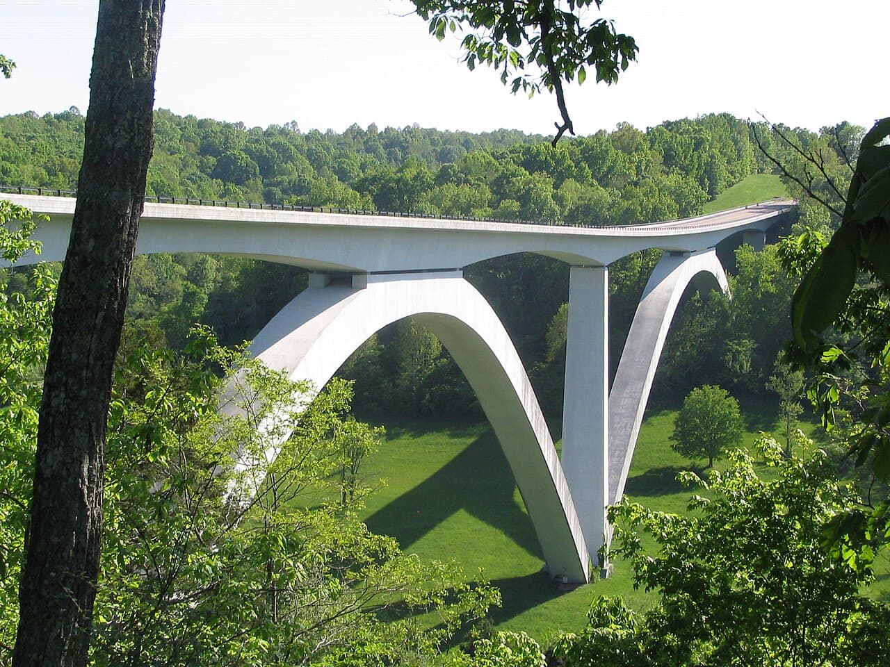
Two closures are live as this is written and both are worth checking before you commit. The Double Arch Bridge and the parkway either side of it, milepost 437 to 440, shut on 15 April 2026 and are expected to stay shut until spring 2027 while a permanent pedestrian safety barrier replaces a temporary one; the detour runs about seven and a half miles and is signed. Separately, a twenty-four mile section between mileposts 135 and 159.5 in Leake and Attala counties closed on 3 August 2026 for full-depth reconstruction, with a detour on the state highways costing about eleven minutes. The park's road and site status page is the only thing worth trusting on the day.
The mileposts count up from Natchez. Milepost 0 is the southern end and 444 is the northern, which means that driving out of Nashville, as this guide does, the numbers count down at your shoulder. Every site is signed by its milepost and the Park Service indexes everything that way, so those are the numbers used here.
The road under the road
Before it was anything else it was a line of high ground. A ridge runs from the Mississippi bluffs northeast toward the salt licks of middle Tennessee, staying above the swamps and crossing the fewest rivers, and animals found it first. Bison walked it to the salt. People followed the bison, and by the time the Choctaw, Chickasaw and Natchez were living along it the path had been in use for thousands of years. The Chickasaw called it after Piomingo, whose road it effectively was.
Its busiest years were short and strange. From the 1780s, farmers and traders from Kentucky, Ohio and Tennessee floated produce down the Mississippi on flatboats to Natchez and New Orleans, and since a flatboat cannot be rowed back up the river, they broke it up, sold the lumber, and walked. The Trace was the way home: some 450 miles on foot or horseback, two to three weeks of it, through country with almost nothing on it. They were called Kaintucks whatever state they came from, and by 1810 an estimated ten thousand of them were making the walk every year.
Traffic on that scale needed a road, so Jefferson made one. He called it the Columbian Highway, and from 1801 the army worked along the route clearing and bridging until, by 1809, a wagon could get through. Inns appeared at intervals, called stands, offering hominy, bacon, coffee, whiskey and a place on the floor. So did the other kind of business: the route was remote and everyone on it was carrying the proceeds of a sold cargo, which is how it got the name the Devil's Backbone and how Samuel Mason, the Harpe brothers and later John Murrell made a living from it.
Then it ended, quickly, and for the best possible reason. The steamboat made the Mississippi a two-way river, and a Kaintuck could ride home in comfort with his money in his pocket instead of walking three weeks with it. By the 1820s the traffic had gone and by the 1830s the road was already going back to the woods. The Trace had spent forty years opening up a country that promptly found better ways to get around.
Whose ground it crosses
The road passes three separate civilizations of mound builders and they are further apart in time than we are from any of them. Pharr Mounds, near milepost 286.7, is eight burial mounds over ninety acres, raised between about 1 and 200 of the common era by Miller culture people whose graves held copper ear spools traded down from the Great Lakes. Bear Creek Mound went up somewhere between 1100 and 1300. Emerald Mound, eight acres of flat top near the southern end, was in use from around 1250 to 1600. Eleven hundred years separate the first from the last.
By the time the Kaintucks came through, this was Chickasaw and Choctaw country and remained so legally as well as practically. The road existed on their land by treaty, and the sections that ran through the Chickasaw and Choctaw nations were governed by agreements the United States negotiated rather than by anything it could simply take. George Colbert's ferry at the Tennessee River, the Choctaw agency near milepost 100, and the village outlines at Tupelo are all pieces of that arrangement.
It did not last, and the parkway does not hide how it ended. Colbert, who had led Chickasaw troops under Jackson in the Creek War, signed the 1834 treaty that set his own nation's removal in motion and died in Indian Territory in 1839 before reaching the new land. At milepost 328.7 there is an overlook onto the Tennessee River, and what it marks is the water route of the Trail of Tears. The road that had carried the nation's traffic became, within a generation, the road out.
The other history along here is written in the same ground. Mount Locust was a working plantation as well as an inn, and forty-three enslaved people are buried west of the house; some of them made the bricks it is built from. Rocky Springs, at its 1860 peak, counted 2,616 residents and roughly 2,000 enslaved people who were not counted as residents. The parkway runs quietly through all of it, and the site markers are more forthright about it than they used to be.
Twelve regions in one drive
The Park Service counts four ecosystem provinces, eight major watersheds and twelve physiographic regions on this one road, and of its 52,000 acres nearly 39,000 are in something like natural condition, which makes the parkway an almost unbroken greenway 444 miles long. The forest changes under you as you go: oak and beech in the south, oak and pine through the middle, oak and hickory by the Tennessee end.
The southernmost stretch is built on dust. During the ice ages, wind carried silt off the plains and dropped it across this part of Mississippi to a depth of thirty to ninety feet. Loess is the result, and it behaves like nothing else: it stands in vertical walls when it is dry and washes away under any traffic at all. That is why the Old Trace here is not a path but a trench, sunk in places twenty feet below the ground it crosses, and why the bluffs above Natchez have the ravines they do.
The middle of the road is water and prairie. Around Tupelo the parkway crosses blackland prairie, dark heavy soil that supported grass rather than forest and now supports the Chickasaw Village Site's ninety acres. Further south the Pearl River has wandered enough to leave old channels behind it, and one of them at milepost 122 is a cypress swamp with alligators in it, reachable by boardwalk in twenty minutes.
North of the Tennessee River the country lifts onto the Highland Rim, and the parkway starts behaving like a mountain road: bluffs, hollows, and creeks with waterfalls in them, of which Jackson Falls is the one everybody stops at. Deer graze the verges at dawn and dusk in numbers that should make you careful, wild turkey work the field edges, and the roadside planting flowers hard from March: redbud and dogwood first, then everything else.
Getting out of the car
There is a National Scenic Trail here as well as a parkway, and hardly anybody knows it. The Natchez Trace National Scenic Trail runs in five sections totalling about sixty-five miles, roughly parallel to the road: the Highland Rim near Leiper's Fork at about twenty-five miles, Blackland Prairie near Tupelo at six, Yockanookany at twenty-four, Rocky Springs at nearly ten, and Potkopinu at three. Potkopinu is the one to walk if you only walk one, because it is sunken trace the whole way.
For anyone not committing to that, the short walks are the point of the drive. Sunken Trace at milepost 41.5 is a few hundred yards and shows you more than any exhibit. The Cypress Swamp boardwalk is twenty minutes. Jackson Falls is nine hundred feet down and nine hundred feet back up. Old Trace segments are signed at intervals the whole length of the road, some of them drivable, most of them a five minute walk into the woods on the actual thing.
The parkway is also one of the best long-distance cycling routes in the country, and for structural reasons rather than scenic ones: no commercial traffic at all, a 50 mph limit, gentle grades, and three free campgrounds spaced along it at mileposts 385.9, 193.1 and 54.8. The Park Service designates the entire road as a bike route. The catch is the same one drivers have, which is that there is nowhere on it to buy anything.
How long to give it
Half a day
The Tennessee end, out of Nashville and back. This is the hilliest, most obviously pretty stretch of the whole parkway and it is on the doorstep of a city, which is why it carries most of the day traffic. Note that the bridge and its overlook are inside the 2026 to 2027 closure, so until that lifts, join at Highway 96 and drive south.
Double Arch Bridge · Gordon House · Jackson Falls · Meriwether Lewis
Two days
The whole road, which is the honest minimum. Leave Nashville early, take the Tennessee sites in the morning, cross the Tennessee River at Colbert Ferry around the middle of the day, and sleep in or near Tupelo. The second day is longer and quieter: mounds, prairie, swamp, and the loess country at the end of it.
Double Arch Bridge · Jackson Falls · Meriwether Lewis · Colbert Ferry · Chickasaw Village Site · French Camp · Cypress Swamp · Rocky Springs · Mount Locust · Emerald Mound
Four days
The version the road is actually built for, at roughly a hundred miles a day with time to walk. Nights around Hohenwald or Florence, Tupelo, and Jackson or Port Gibson, finishing in Natchez with a day there. At this pace you can take the Old Trace segments as they come rather than choosing between them, and the three free campgrounds fall almost exactly where you want them.
Double Arch Bridge · Gordon House · Jackson Falls · Meriwether Lewis · Colbert Ferry · Bear Creek Mound · Chickasaw Village Site · Jeff Busby · French Camp · Cypress Swamp · Rocky Springs · Sunken Trace · Mount Locust · Emerald Mound
When to come
Spring is the season this road is famous for and the numbers show it: March through June are the busiest months on the parkway. Redbud and dogwood come first, the wildflower planting along the verges follows, and the whole 444 miles is in leaf before the heat arrives. It is also when the waterfalls are actually running, which matters at Jackson Falls, where the branch feeding it is seasonal.
Autumn is the other good answer, with color working its way down from the Tennessee hills and the humidity finally off. October is when the sorghum mill at French Camp fires up. Summer in Mississippi is hot, humid and prone to afternoon thunderstorms, and the swamp is at its least inviting. Winter strips the woods back so you can see the shape of the country and the old roadbeds in it, with almost nobody else out there, at the cost of shorter days and reduced hours at the visitor contact points.
Know before you drive
- There is no fuel, no food and no lodging anywhere on the parkway itself, by design. Exits to towns come every thirty to fifty miles. Fill the tank before you join and know where your next exit is rather than finding out.
- Cell signal comes and goes, and through rural Mississippi it mostly goes. Download offline maps first.
- The mileposts count up from Natchez, so heading south from Nashville they count down. Every site is signed by milepost and that is how the Park Service indexes them, so the milepost is what to search for.
- Camping is free at all three parkway campgrounds, at mileposts 385.9, 193.1 and 54.8. First come first served, no reservations, no electricity, no showers, no dump stations, fourteen nights a year per campground. Dispersed camping is not allowed anywhere on the parkway.
- There is no entrance fee, nothing to reserve and no permit needed to drive it.
- Check the park's road and site status page the week you travel. As of August 2026 the Double Arch Bridge section is shut until spring 2027 and a twenty-four mile stretch between mileposts 135 and 159.5 is under reconstruction into late 2026.
- Deer are on the verges at dawn and dusk the whole length of the road, and the speed limit is doing two jobs.
In an RV or with a trailer
The ban is on commercial traffic, not on motorhomes, and the parkway is a favorite: no trucks, gentle grades, and long sight lines. The limits are 55 feet including anything towed, 14 feet of height, and 40,000 pounds, with some bridge clearances under 15 feet; trucks over one ton rated capacity are not allowed at all. The three parkway campgrounds have no hookups, showers or dump stations, so plan those into the towns off the road.
Questions
- How long does it take to drive the Natchez Trace Parkway?
- About ten hours of pure driving for all 444 miles at the 50 mph limit, which nobody does. Two days is the realistic minimum if you want to get out of the car at all, and three or four is what the road rewards. Current construction detours add roughly twenty minutes in total.
- Is there anywhere to buy gas or food on the parkway?
- No. Commercial development is prohibited along the entire route, so there are no gas stations, restaurants or shops on the parkway itself. Exits to nearby towns come every thirty to fifty miles. French Camp at milepost 180.7 is the one place with a cafe close enough to walk to.
- Can you still see the original Natchez Trace?
- In many places, yes, and it is the best thing on the road. Segments of the Old Trace are signed the whole length of the parkway, some drivable and most a short walk. The clearest are the sunken sections in the loess country south of Jackson, where the original road runs in a trench well over head height, and the Potkopinu section of the National Scenic Trail, which is three miles of it.
- Is the Double Arch Bridge open?
- Not at the moment. The bridge and the parkway between mileposts 437 and 440 closed on 15 April 2026 to all traffic, including pedestrians and cyclists, while a permanent pedestrian safety barrier is installed, and the Park Service expects it to reopen in spring 2027. A signed detour of about seven and a half miles is in place. Check the park's road and site status page before traveling.
- Does it cost anything, and do you need to book?
- No on both counts. There is no entrance fee for the parkway or any of its sites, and the three campgrounds are free and first come first served with no reservation system. The only limits are fourteen nights a year per campground and no dispersed camping.
Sources: Natchez Trace Parkway, National Park Service, NPS road and site status, Natchez Trace Parkway, Natchez Trace Parkway, Mississippi Encyclopedia, Natchez Trace Parkway, Tennessee Encyclopedia, Natchez Trace National Scenic Trail, National Park Service, Historical Marker Database, Natchez Trace series.
Reviewed August 2026
Hear it from the road
Whistlestop tells you these stories automatically as you pass them. No searching, no tapping, nothing to ask.