Live on the road
Hoover Dam & Lake Mead Audio Tour
Whistlestop narrates far more of the drive than this guide can list, automatically, as you pass each one.

The field guide
The dam
Congress authorised it on 21 December 1928 and the contract went to Six Companies, an alliance of western builders none of whom could have taken it alone. Work started in 1931, seven years were allowed, and it was finished in five: the first concrete went in on 6 June 1933, the last on 29 May 1935, and Roosevelt dedicated it on 30 September that year with the rest of the works completed by March 1936. Twenty-one thousand men worked on it over the course of the job, 5,218 of them on the busiest day in June 1934.
The engineering problem people remember is the heat. Concrete cures by a chemical reaction that gives off warmth, and three and a quarter million cubic yards of it in one mass would have taken generations to cool and cracked itself apart while it did. So the dam was built as a honeycomb of separate columns, each poured in shallow lifts, each threaded with pipe carrying chilled water from a refrigeration plant on site, and the gaps between them grouted only once the blocks had come down to temperature. What looks like a single wall is stacked masonry at heart.
It cost about $49 million and, by Reclamation's official count, 96 lives: 91 of the dead were Six Companies employees, three worked for Reclamation, one was a visitor, and the last for another contractor. That figure counts industrial fatalities at the dam site, which is why a larger number, 112, circulates alongside it; the larger one reaches back to two Reclamation surveyors who drowned in the Colorado in 1922, six years before the dam was authorised at all. Both counts leave out a further 42 men recorded as dying of pneumonia, in a canyon where the July air hit 120 degrees and where, in the first summer alone, sixteen workers and residents died of heat between 25 June and 26 July 1931. The strike that August began over a wage cut and undrinkable water and was broken with clubs; ice-water stations appeared afterwards, along with a faster schedule for finishing Boulder City.
The name went back and forth. Ray Wilbur called it Hoover Dam in September 1930, Harold Ickes changed it to Boulder Dam in May 1933, and Congress put it back in 1947. The money settled more quietly: the power the plant sold paid off the fifty-year construction loan, so the dam bought itself.
The lake, and what is happening to it
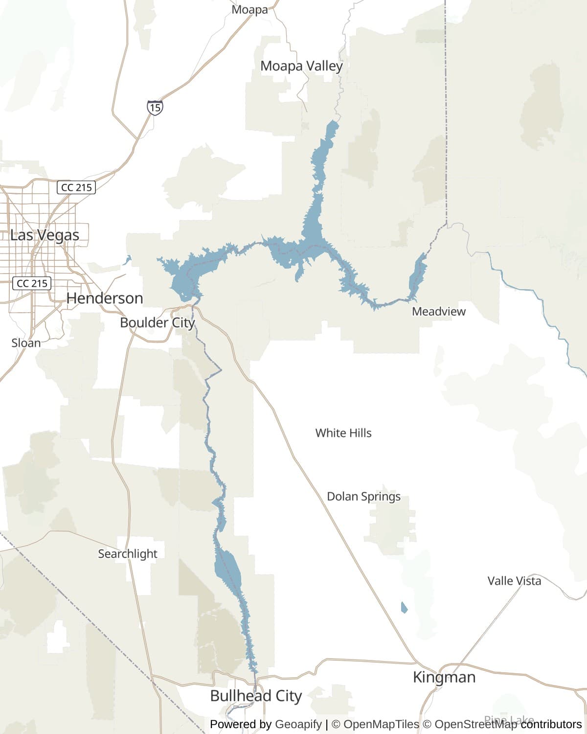
Lake Mead is the largest reservoir in the United States by capacity, 28.23 million acre-feet when full, 247 square miles of surface, and something over a hundred miles from the dam to the far end. Full pool is 1,229 feet above sea level. It began filling on the day the dam was dedicated in 1935 and took until 1938 to swallow what it was going to swallow.
It has not been full since the 1980s. Twenty-five years of a drier Colorado, against water rights allocated in the 1920s on the basis of an unusually wet run of years, have taken it down in steps: 1,071 feet in July 2016, then 1,040.58 on 28 July 2022, which was the lowest since 1937 and stood as the record for four years. Reclamation's weekly report put the lake at 1,040.96 feet and 27 per cent full on 2 August 2026. It went under the 2022 mark early on 7 August, and by 12 August it was at 1,039.82, the lowest the reservoir has been since it first filled.
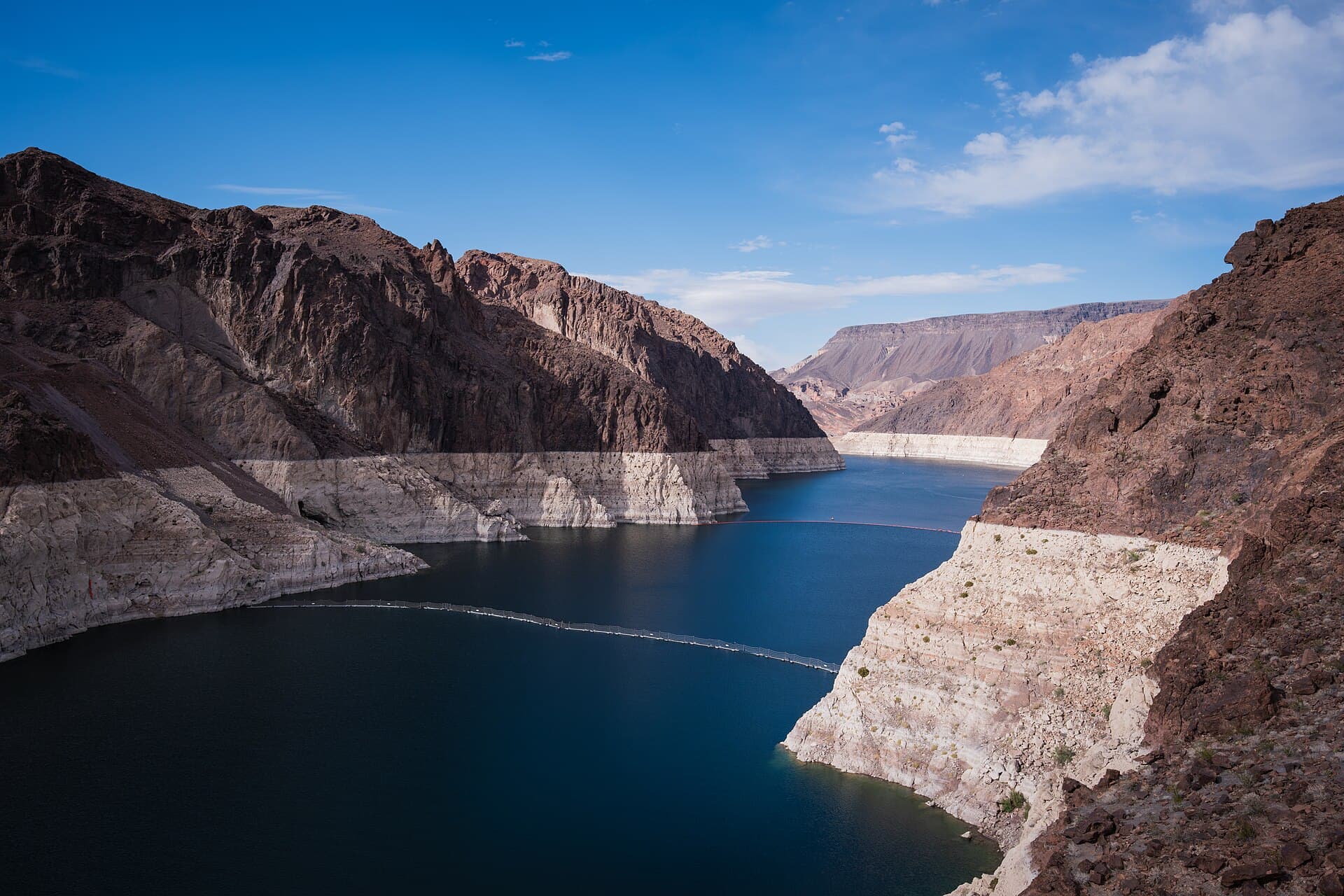
The white band on the cliffs is the arithmetic made visible. It is calcium carbonate out of the river water, laid on the rock while the lake stood higher and left bleached when it dropped, and its top edge is where full pool used to be. The band in the hero photograph above is roughly forty vertical feet of it. Nothing else on this trip will explain the Colorado to you as fast.
The consequences are practical and they arrive in a specific order. Marinas move first: Las Vegas Bay's marina gave up and relocated to Hemenway Harbor, and the launch ramps up and down the lake have been extended, re-poured and abandoned in turn, which is why the current-conditions page is the one to read before towing a boat. Then the power goes. Hoover's output is already something like 40 to 50 per cent below where it was in 2000, because a lower lake means less head on the turbines, and Reclamation puts the hard step at elevation 1,035 feet, below which a dozen of the older machines are not designed to run at all. In August 2026 the lake was about five feet above that line.
Rock, heat and three deserts
Black Canyon is volcanic, and that is why the dam is here rather than anywhere else. The walls are mostly Miocene lava and ash sitting on much older crystalline basement, some of the deepest of it Paleoproterozoic schist and gneiss between 2.5 and 1.6 billion years old. Above the dam on the Arizona side, Fortification Hill is a mesa capped by a basalt flow, the flat black lid you can see from the bridge. Rock like that is strong, close-grained and narrow at the river, which is exactly what an arch dam needs to push against.
Most of the park sits in the Basin and Range, the stretched and broken country of north-south ranges and sediment-filled valleys that runs from here to Utah, and its eastern edge just reaches the Colorado Plateau at the Grand Wash Cliffs. That boundary is why the lake's far end looks like a different landscape from its near end.
Three deserts meet inside the recreation area, which is unusual and which is most of the reason the plant list runs to about 900 species. The Mojave holds the middle of it, with the Great Basin arriving from the north and the Sonoran from the south, and the ranges are high enough and the springs numerous enough for each to keep a foothold. What all three agree on is the heat. Summer highs above 110 are routine and the canyon floor has approached 130; the shade the trail tunnels offer is not a nicety.
Who was here, and what went under
This is Southern Paiute country on the north and west of the river, Mojave country along the lower Colorado, and Hualapai country to the east, with the Chemehuevi holding the southern end of the Southern Paiute range. They were here when the Spanish arrived and their descendants are here now, and the Park Service's own ethnographic overview of the recreation area is built around the Chemehuevi, Southern Paiute and Hualapai rather than around the dam.
Long before any of them, the Ancestral Puebloan settlements along the Muddy and Virgin rivers made up what archaeologists named Pueblo Grande de Nevada and newspapers called the Lost City. It was identified in 1924. When the dam was authorised it became obvious that most of it was going to be at the bottom of a reservoir, and the 1930s excavations there were an outright race, funded through the New Deal, to get material out of the ground before the water arrived. The museum at Overton is where it went, and the building itself was thrown up by the Civilian Conservation Corps in 1934 and 1935 for that purpose.
The lake took modern towns too. St. Thomas was founded by Mormon settlers in 1865, who packed up and went back to Utah in the early 1870s when a boundary survey put them in Nevada and the taxman with them, and who drifted back after 1880. It had a hotel, a school and a railway stop. The water reached it in 1938 and the last resident, Hugh Lord, rowed away from his own front door. Callville, further west, had already died twice over: a river port founded in 1864 that saw a steamboat in 1866 and was empty by about 1869, now under silt.
Boulder City is the town the dam built and kept. Reclamation laid it out in 1931 on federal land, with a designed street plan, government-built houses, and a federal ranger to enforce a ban on the drinking and gambling that were the whole economy thirty miles away. It only became an ordinary municipality in 1960, and it has kept the gambling ban voluntarily ever since, which makes it one of two towns in Nevada without a slot machine in it.
Getting out on it
Lake Mead National Recreation Area covers 1,495,806 acres, which makes it one of the largest units in the park system and one of the busiest, with about six and a half million visits a year. It was set up in 1936 as the Boulder Dam Recreation Area under an agreement between the Park Service and Reclamation, renamed in 1947 when the dam got its own name back, and in 1964 became the first national recreation area established by an act of Congress. It holds two reservoirs, not one: Lake Mead behind Hoover, and Lake Mohave behind Davis Dam sixty-odd miles downstream.
The best water in the park is arguably the river rather than the lake. Below the dam the Colorado runs clear, cold and moving through Black Canyon, past hot springs that come out of the same faulted volcanic rock, and thirty miles of it were designated a national water trail in 2014. Launching at the dam is capped at thirty boats a day and needs a permit six months out through one of a handful of outfitters, who bus you down through the security zone. Going upstream from Willow Beach needs nothing at all, which is how most people do it.
The wildlife is desert wildlife plus whatever the reservoir allowed. Desert bighorn work the ridges above the shoreline and are genuinely common here. The razorback sucker, a three-foot Colorado River fish that can live forty years, was thought locally extinct by the 1970s and now has a self-sustaining population in the lake. The relict leopard frog was believed extinct for decades and survives in a handful of springs mostly inside this park. Going the other way, quagga mussels turned up on 6 January 2007, the first sighting west of the Rockies, and they are the reason your boat gets inspected and why you should not move it between waters without drying it out.
How long to give it
Half a day
The dam and nothing else, which is what most people who come here do. Park in the garage on the Nevada side, take a tour, walk out onto the bridge for the view back, and if there is time left, walk into the first railroad tunnel. Boulder City is ten minutes away and is where to eat.
Hoover Dam · Mike O'Callaghan and Pat Tillman Memorial Bridge · Historic Railroad Trail · Boulder City
One day
The dam in the morning, then out along Northshore Road in the afternoon, which is the drive that shows you the lake as a thing in a landscape rather than as a view from a car park. Turn at Echo Bay or carry on to St. Thomas and walk down into the town. Overton has the museum and the last fuel.
Hoover Dam · Hemenway Harbor and Boulder Beach · Callville Bay · Echo Bay · St. Thomas · Lost City Museum
Three days
One day on the dam and the Nevada shore, one on the Overton Arm, and one below the dam on the river: a paddle out of Willow Beach, then south down Lake Mohave to Cottonwood Cove and Katherine Landing. Each of those three is a different body of water and they do not feel remotely alike. Distances are long and unpeopled, so treat fuel as a planning constraint rather than an errand.
Hoover Dam · Boulder City · Hemenway Harbor and Boulder Beach · Echo Bay · St. Thomas · Willow Beach · Cottonwood Cove · Katherine Landing
When to come
Come between October and April. Summer here is not an inconvenience, it is a hazard: highs above 110 are ordinary, the canyon floor has approached 130, and the exposed shoreline trails have no shade and no water on them. The park's own advice in summer amounts to being on the water or being indoors by mid-morning.
Spring is the best of it, with warm water arriving before the air becomes punishing and the desert in flower after a wet winter. Autumn runs it close and is quieter. Winter is genuinely pleasant for walking, with cold nights, short days and the lowest visitation of the year, though the water is too cold for most people and some concessionaire services run reduced hours.
Know before you drive
- Entrance to the recreation area is $25 per vehicle for up to seven days, $20 per motorcycle, or $15 on foot or by bicycle; an annual pass for the park is $45. The park is cashless and takes cards only.
- Hoover Dam is Reclamation, not the Park Service, and charges separately: the visitor center and observation deck are $15, the guided powerplant tour $25 for adults and $15 for ages 4 to 16, and the full dam tour $40, sold on the day at the desk and not bookable. Parking in the Nevada garage is $10. Tours run 9 a.m. to 5 p.m. with the last one at 4:10, and you must be 16 to go round unaccompanied.
- Every vehicle approaching the dam goes through a security checkpoint. No drones anywhere near it, and no pets beyond service animals.
- Boats pay separately: $16 per vessel for seven days, or $50 for the year. Expect an invasive species inspection, which exists because of the quagga mussels and is not optional.
- Launch ramps change with the water. Check the park's current conditions page in the week you travel rather than trusting anything printed, including this. In August 2026 every ramp on both lakes was usable but several were down to one lane.
- Fuel and supplies are thin once you leave Boulder City or Overton. Temple Bar, South Cove and the Northshore Road have long empty stretches, and phone signal goes with them.
- Carry far more water than feels reasonable, and do not start a shoreline walk late in the day between May and September.
In an RV or with a trailer
This is easy RV country: wide roads, big lots at the dam on the Arizona side, and developed campgrounds at Boulder Beach, Callville Bay, Echo Bay, Temple Bar, Willow Beach, Cottonwood Cove and Katherine Landing, most with concessionaire RV parks alongside offering hookups and dump stations. The exception is the dam itself, where the Nevada parking garage has a height limit and oversized vehicles are directed to the surface lots on the Arizona side.
Questions
- Can you still drive across Hoover Dam?
- Yes, but it is no longer a through route. US 93 has crossed the bypass bridge since October 2010, and the road onto the dam is now a spur from the Nevada side that ends in Arizona parking. Every vehicle passes a security checkpoint, and the crest road closes overnight.
- Do you need to book a Hoover Dam tour?
- No, and mostly you cannot. Tickets are sold at the visitor center on the day, first come first served, and the guided dam tour in particular cannot be reserved in advance. Arrive early, especially in spring. The exception is paddling: launching a boat at the dam is capped at thirty a day and is booked months ahead through an outfitter.
- How low is Lake Mead, and can you still boat on it?
- In August 2026 it fell to about 1,040 feet above sea level and roughly 27 per cent of capacity, the lowest since it first filled in the 1930s, against a full pool of 1,229 feet. You can still boat: as of that month every launch ramp on Lake Mead and Lake Mohave was open, though several were reduced to a single lane and the park recommends shallow-hulled boats at Hemenway Harbor. Check the park's conditions page before you tow anything.
- What is the white ring around the lake?
- Calcium carbonate from the Colorado River, deposited on the rock while the water stood higher and left behind, bleached, as the lake dropped. The top of the band marks full pool at 1,229 feet. It is the clearest thing to look at in the whole park and it is entirely free.
- Is Lake Mead a national park?
- It is a national recreation area, which is a different designation with a different purpose: it is managed for recreation as well as preservation, so motorboats, water skiing and hunting are permitted where they would not be in a national park. It was established in 1936, and in 1964 became the first national recreation area created by an act of Congress.
Sources: Hoover Dam, Bureau of Reclamation, Fatalities at Hoover Dam, Bureau of Reclamation, Reclamation, Lower Colorado weekly water report, Lake Mead National Recreation Area, National Park Service, NPS current conditions, launch ramps and closures, NPS Geodiversity Atlas, Lake Mead National Recreation Area, Lake Mead National Recreation Area: An Ethnographic Overview, NPS, Quagga mussels on the lower Colorado River, Reclamation.
Reviewed August 2026
Hear it from the road
Whistlestop tells you these stories automatically as you pass them. No searching, no tapping, nothing to ask.