Live on the road
Going-to-the-Sun Road Audio Tour
Whistlestop narrates far more of the drive than this guide can list, automatically, as you pass each one.

The field guide
When the road actually opens
The low miles at each end, from West Glacier to Lake McDonald and beyond, and from St. Mary up the lake, are open all year. The alpine section in the middle, over Logan Pass, is not. The park sets no opening date for it and says that none can be predicted: it opens when the plows are through, and the plows are at the mercy of the snow.
Plowing usually starts in the first week of April and runs until the pass opens. Crews work with avalanche spotters above them and stop when slopes are unsafe, re-plow whatever the next storm refills, and have to dig through the Big Drift just east of the pass, where wind stacks the snow sixty to eighty feet deep over the road. Before the road opens to cars, parts of it open to walkers and cyclists, which is its own way of seeing it.
So the honest answer is the record. Over the twenty seasons from 2006 to 2026, leaving out 2020, the road opened fully over Logan Pass as early as 13 June (2023) and as late as 13 July (2011 and 2022), and the median date was 22 June. Fifteen of those twenty seasons were open before July. It opened on 22 June in 2026, 16 June in 2025 and 22 June in 2024. In 2020, for the first time in its history, part of the road never opened at all.
It has been earlier. In the 1940s and 1950s the pass often opened in late May or early June, and in 1987 on 16 May. The road itself has also cost time: a multi-year rehabilitation, roughly $80 million of work since 2007, closed one side or the other early in several autumns and delayed at least one opening.
The road stays fully open, weather permitting, until the third Monday of October, a closing date set in 1992. Weather decides much more often than the calendar. In 2025 snow shut the alpine section on 4 October, it reopened on the 8th, and it closed for the season on the 14th. In September 2026 heavy rain and then snow each closed the alpine section. If your trip depends on the pass, check the park's road status page on the morning, not the week before.
Building it into the wall
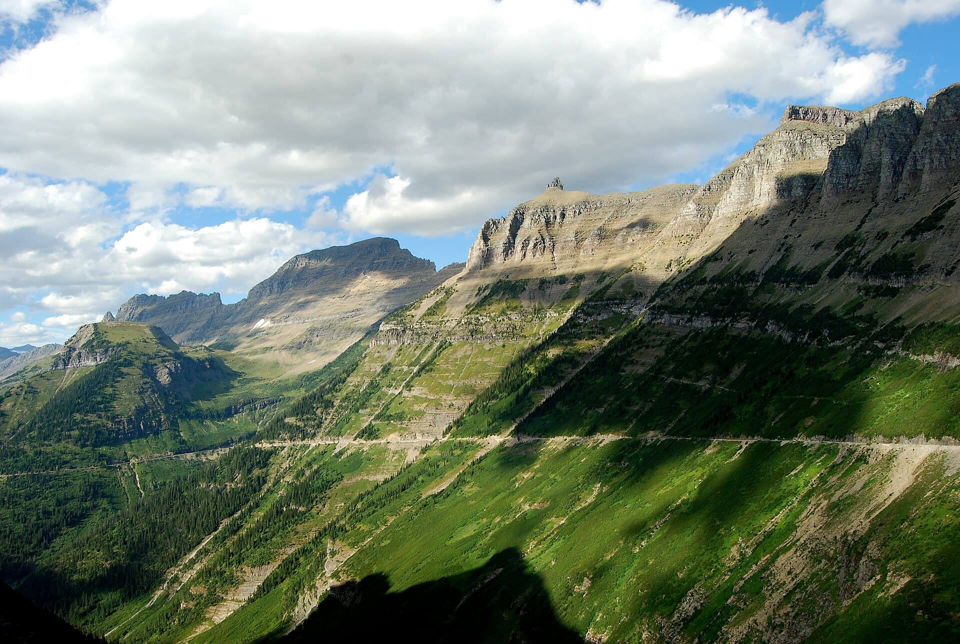
The route was surveyed in 1918 and work began in 1921. The Park Service's chief engineer, George Goodwin, had planned to climb the Logan Creek valley to the pass in a series of switchbacks. In the summer of 1924 the director, Stephen Mather, rode up to look at it with Goodwin and the landscape engineer Thomas Vint, and Vint objected that switchbacks would make the valley look as if miners had been in there. He proposed cutting the road straight into the cliffs of the Garden Wall instead, and leaving the valley below it alone.
Mather brought in the Bureau of Public Roads, whose engineer Frank Kittredge surveyed the route that autumn with crews who climbed some 2,700 feet each morning before they started work and quit only when four feet of snow fell in November. Kittredge strongly recommended Vint's line. It would be the more expensive road, he wrote, but it would hold the snow off longest, could be improved later, and would show the park off best. That decision, and the agreement between the two agencies that came out of it, set how national park roads were built for the next quarter century.
Twelve of the fifty miles were blasted out of the mountainside with power shovels, pneumatic drills and close to half a million pounds of explosives. Masonry gangs, among them Russian, Italian and Irish immigrants, laid the bridges, culverts and guardwalls by hand in the local stone. Bears raided the camps. Three men died: one fell from the rope he was hanging on to inspect an overhang, one was hit by a falling rock, and one was killed in a rockslide.
The whole road was open to traffic in 1932 and dedicated at Logan Pass on 15 July 1933. Goodwin had estimated it at about $600,000. It cost more than $2.5 million. Work on the roadbed and the stonework went on until 1955, when the last section was paved. It is a National Historic Landmark and a National Historic Civil Engineering Landmark, and the director's letter read at the dedication said what it was meant to be: the one road across a park that would otherwise stay trail country.
Whose land, and whose name
The land the park covers is part of the history and culture of the Blackfeet, Salish, Pend d'Oreille and Kootenai peoples. The Blackfeet Reservation adjoins the whole east side of the park and the Flathead Reservation of the Confederated Salish and Kootenai Tribes lies to the southwest.
Everything east of the Continental Divide was Blackfeet land until 1895. Under pressure from miners hunting copper and gold, the government bought the mountains in the Agreement of 1895 for $1.5 million, and the agreement kept for the Blackfeet the right to hunt, fish and cut timber there for as long as it stayed public land. The mines came to nothing. Glacier became the country's tenth national park in 1910, and the rights the Blackfeet had kept were soon treated as gone. Many Blackfeet read the agreement differently from the government to this day.
The road takes its name from Going-to-the-Sun Mountain above St. Mary Lake, and the name has layers. The mountain was named in 1888 by James Willard Schultz, a writer and guide who lived among the Blackfeet and said it came from a story of Napi, the Old Man, returning to the sun. The story most travel pages tell, of a spirit who came down to teach the Blackfeet to hunt and left his face in the snow on the mountain, comes from a 1933 Interior Department press release written for the road's dedication. Congressman Louis Cramton and the park naturalist George Ruhle are both credited with putting the name on the road.
Rock from a shallow sea, and ice that is leaving
The cliffs the road is carved into began as mud and lime on the floor of a shallow sea about a billion and a half years ago, when this part of the world looked more like the Bahamas. The red and green rocks in every stream bed are those old muds, now argillite. The limestone of the Siyeh Formation, exposed along the road beside the Garden Wall, is full of stromatolites, mounded fossil mats of blue-green algae, among the oldest fossils in any national park. Mountain-building later shoved these ancient layers east on top of much younger rock, the reverse of the usual order.
The ice shaped the rest. Glaciers up to 3,000 feet thick filled the McDonald valley as recently as about 12,000 years ago and ground it into the broad U the road climbs out of; smaller glaciers left hanging valleys high on the walls, which is why so many waterfalls here drop off cliffs. At the end of the Little Ice Age, around 1850, there were an estimated 150 glaciers in what became the park. In 2015, 26 were still large enough to count. Jackson Glacier Overlook is where the road lets you see one.
Two sides of the Divide, and what lives on them
Crossing Logan Pass is crossing a climate. Pacific weather stalls against the Divide and drops its rain on the west side, which is why cedar and hemlock grow around Avalanche Creek. The east side is dry and windy, and the forest thins quickly toward the prairie that begins at the park boundary.
The mountain goat is the park's symbol, and it is not a goat: it is the only living member of its genus and closer kin to the chamois of Europe than to any farmyard animal. At Oberlin Bend and around Logan Pass they are all but guaranteed, bighorn sheep too if you look carefully. Hoary marmots and Columbian ground squirrels work the meadows. Do not feed any of them and do not approach; if one comes toward you, move away.
Grizzly bears are often seen on the east side around Two Dog Flats, and black bears on both. The whole park is bear country: carry bear spray on any trail, make noise, and never leave food unattended.
How long to give it
Half a day
One side to the pass and back. From the west, the Trail of the Cedars, the tunnel and the Loop, the Weeping Wall and Triple Arches to Logan Pass. Leave very early: the lot at the top is often full by sunrise, and in 2026 private cars could stay only three hours from July to Labor Day.
Apgar Village · Trail of the Cedars and Avalanche Creek · West Tunnel · The Loop · Weeping Wall · Triple Arches · Logan Pass
One day
End to end, west to east, the direction the mileposts count. Two hours of driving without stopping; give it the whole day.
Apgar Village · Lake McDonald Lodge · Trail of the Cedars and Avalanche Creek · The Loop · Triple Arches · Logan Pass · Jackson Glacier Overlook · Sun Point · Wild Goose Island · St. Mary Visitor Center
Two or three days
Base on the west side one night and the east side the next. That leaves room for Avalanche Lake, the Hidden Lake Overlook, St. Mary and Virginia Falls, a boat on St. Mary Lake, and an early morning at Two Dog Flats. For the Highline, book the park's shuttle.
Apgar Village · Lake McDonald Lodge · Trail of the Cedars and Avalanche Creek · West Tunnel · The Loop · Bird Woman Falls · Weeping Wall · Triple Arches · Logan Pass · Big Drift and the East Tunnel · Jackson Glacier Overlook · St. Mary Falls · Sunrift Gorge · Sun Point · Wild Goose Island · Rising Sun · Two Dog Flats · St. Mary Visitor Center
When to come
The whole road is usually open from late June to the third Monday of October, and that is the only window in which you can drive it end to end. Plan for the second half of that window if the crossing is the point of the trip: a late June arrival in a big snow year can still find the pass closed.
July brings the wildflowers at Logan Pass as the snow goes, and the biggest crowds. In early summer the snow lingers on the trails at the top well into July, and the Highline is often closed until it melts.
September is quieter and often clear, but the high road can close for days at a time for snow or rain long before its official closing date, as it did twice in September 2026. The park's shuttles and the Logan Pass parking limit both ended at Labor Day in 2026.
Know before you drive
- The summer entrance fee is $35 per private vehicle for seven days ($25 from November through April). Since 2026 non-US residents aged 16 and over also pay $100 each unless they hold an annual or America the Beautiful pass.
- No vehicle reservations were required anywhere in the park in 2026, for the first time in several years. Instead the park limited private cars at Logan Pass to three hours and ran a ticketed-only Logan Pass Shuttle, booked on recreation.gov, both from 1 July to 7 September. The system has changed every year lately; check the park's site before you go.
- There is no gasoline in the park. There is an electric vehicle charger across from the Lake McDonald Lodge camp store.
- The speed limit is 40 miles an hour on the lower road and 25 in the alpine section. Driven without stopping, the whole fifty miles takes about two hours.
- Food and lodging along the road are at Apgar, Lake McDonald Lodge and Rising Sun, in summer only. Five campgrounds sit on the road: Apgar, Sprague Creek, Avalanche, Rising Sun and St. Mary.
- In summer, bicycles are barred from the Apgar turnoff to Logan Pass between 3 and 6 in the afternoon, and some sections under repair may be gravel.
In an RV or with a trailer
Vehicles or combinations longer than 21 feet including bumpers, or wider than 8 feet including mirrors, are prohibited between Avalanche Creek and Rising Sun, so an RV or a trailer cannot cross the pass at all; drive to either end, and cross in a car, on the park shuttle or on a red bus tour. Anything over 10 feet tall may also struggle under the rock overhangs between Logan Pass and the Loop, and Sprague Creek campground takes no towed units.
Questions
- When does Going-to-the-Sun Road open?
- There is no set date; it opens over Logan Pass when the plows finish. From 2006 to 2026 (leaving out 2020) the full road opened as early as 13 June and as late as 13 July, with a median of 22 June, and it was open before July in fifteen of those twenty seasons. It opened on 22 June in 2026. The lower sections at both ends are open all year.
- When does Going-to-the-Sun Road close?
- It stays fully open, weather permitting, until the third Monday of October. Snow often closes the alpine section earlier, sometimes for a few days and sometimes for the season: in 2025 it closed for good on 14 October.
- Do you need a reservation to drive Going-to-the-Sun Road?
- Not in 2026. The park dropped vehicle reservations that year and instead limited parking at Logan Pass to three hours from 1 July to 7 September, with a ticketed shuttle for longer hikes. It has changed the system every year recently, so check before you go.
- Can you drive an RV on Going-to-the-Sun Road?
- Only on the lower ends. Vehicles longer than 21 feet or wider than 8 feet, mirrors and bumpers included, are prohibited between Avalanche Creek and Rising Sun, which covers the whole crossing of Logan Pass.
- Who is Logan Pass named for?
- Major William R. Logan, the first superintendent of Glacier National Park, from 1910 until his death in 1912, nine years before work on the road began.
Sources: NPS, Going-to-the-Sun Road general information, NPS, Logan Pass opening and closing dates, NPS, Going-to-the-Sun Road open for the 2026 season, NPS, Visiting Logan Pass in 2026, NPS, Going-to-the-Sun Road: A Model of Landscape Engineering, NPS, Going-to-the-Sun Road Historic District cultural landscape, NPS, Going-to-the-Sun Road audio tour, NPS, The stromatolites of Glacier National Park, NPS, Entrance fees.
Reviewed September 2026
Hear it from the road
Whistlestop tells you these stories automatically as you pass them. No searching, no tapping, nothing to ask.